 Munnar is situated at the confluence of three mountain streams - Mudrapuzha,
Nallathanni and Kundala. 1600 m above sea level, this hill station was once
the summer resort of the erstwhile British Government in South India.
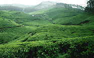
Sprawling tea plantations, picture-book towns, winding lanes and holiday
facilities make this a popular resort town. Among the exotic flora found in
the forests and grasslands here is the Neelakurinji. This flower which
bathes the hills in blue every twelve years, will bloom next in 2006 AD.
Munnar also has the highest peak in South India, Anamudi, which towers over
2695 m. Anamudi is an ideal spot for trekking.
Munnar is situated at the confluence of three mountain streams - Mudrapuzha,
Nallathanni and Kundala. 1600 m above sea level, this hill station was once
the summer resort of the erstwhile British Government in South India.
Sprawling tea plantations, picture-book towns, winding lanes and holiday
facilities make this a popular resort town. Among the exotic flora found in
the forests and grasslands here is the Neelakurinji. This flower which
bathes the hills in blue every twelve years, will bloom next in 2006 AD.
Munnar also has the highest peak in South India, Anamudi, which towers over
2695 m. Anamudi is an ideal spot for trekking.
General
Info. :
Altitude: 5000 to 8000 ft. above sea level
Rainfall: 275 cm
Accessing Munnar :
Road: Distance from Munnar to different tourist centres
Goa: 930 km
Chennai: 600 km
Kozhikode: 289 km
Kollam:
252 km
Malampuzha: 230 km
Palakkad: 226 km
Alappuzha: 200 km
Kodaikanal: 195 km
Kumarakom: 160 km
Madurai: 160 km
Thrissur:
158 km
Kottayam: 147 km
Ooty: 146 km
Palani: 122 km
Thekkady:
110 km
Vaiga Dam: 105 km
Thodupuzha: 91 km
Amaravathy Dam: 80
km
Theni: 70 km
Idukki: 60 km
Chinnar: 60 km
Marayoor:
40 km
Top Station: 34 km
Kundala: 28 km
Anamudi: 20 km
Rajamala:
15 km
Mattupetty: 13 km
Devikulam: 7 km
Pallivasal: 6 km
Pothamedu:
3 km