Ladakh Travel Guide
---------------------------------------------------------------------------------------------------------------------------------------------------------------------------------------------------------------------------------
Ladakh Home » About Ladakh Travel Guide » Religion & Culture » Historical Background » Ancient Routes » Modern Routes
Central Ladakh » Fairs & Festivals » Oracles & Astrologers » Arts & Crafts » Cultural Tourism » Archery & Polo » Adventure in Ladakh
The New Areas » Tourist Information » Air Line Ticketing » Car Coach Rentals In Ladakh
Travel Agents & Tour Operators in Ladakh » Hotels & Resorts in Ladakh » Map »Travellers Tools
---------------------------------------------------------------------------------------------------------------------------------------------------------------------------------------------------------------------------------
The New Areas
Nubra Valley Circuit
Leh - Khardung-la Khalsar-Tirit-Tegar-Sumur-Panamik and return
Leh-Khardung-la - Khalsar- Deskit - Hundar and return.
The upper Shayok and Nubra rivers drain the east and west sides of the Saser Spur, the eastern most outcrop of the Karakoram. The name Nubra is applied to the district comprising the valley of the Nubra river, and that of the Shayok both above and below their confluence, where they meander in many shifting channels over a broad sandy plain before flowing off to the northwest to join the Indus in Baltistan.
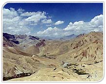
The route from Leh takes the traveler over the Khardung-la, the highest motorable road in the world. The line of the road is different from that of the old pony-trail - longer and actually higher (18,300 feet / 5,578 m). The view from the top of the pass is amazing. One can see all the way south over the Indus valley to the seemingly endless peaks and ridges of the Zanskar range, and north to the giants of the Saser massif. For several kilometres, on each side of the pass, the road covered by deep snow in winter, is rough; for the rest of the way the surface is good.
At the confluence of the two rivers there is no dearth of water, but the sandy soil is not suitable for agriculture, which is confined to the alluvial fans where side streams debouch into the main valley. The valley floor itself is covered with dense thickets of seabuckthorn - a thorny shrub- which the villagers use for fuel and for fencing their fields ; though indeed, there is now less need for this than there was in the days of the caravan trade with Central Asia when up to 10,000 horses a year are said to have traversed the district. The villages are large and seem prosperous, and have thick plantations of willow and popular. The altitude is little less than that of Leh, varying between 10,000 feet (3,048 m) at Hundar, and 10,600 feet (3,231 m) at Panamik. Summer temperatures vary between 15 degree celcuis and 28 degree celcuis.
The main village is Deskit, which has a regular bazaar consisting of a single line of shops, and a gompa. This is situated on a rocky spur above the village with commanding views up and down the valley. From Deskit, the tour circuit proceeds down the Shayok to Hundar, past an area of rolling sanddunes, their contours apparently solid, yet liable to shift with every gale. Here there is a small population of Bactrain camels, shaggy double-humped animals, which in the old days, were used as pack animals on the Central Asian trade routes. During the past 50 years, they have been bred for transport purposes in Nubra; today visitors can take a camel safari out into the dunes from Hundar.
The other circuit proceeds up the Nubra river, taking in the pretty villages of Tirit, Lukung, Tegar and Sumur. Nubra's other kanor monastery, Samstaling is situated on the mountainside just above Sumur. This was the route taken by the trade caravans, and Panamik, the last village on this circuit, wsa at that time a busy centre, the last major settlement before the caravans plunged into the mountains of the Karakoram and the Kun-Lu. Here they invariable halted for a few days to make final preparations for getting over the mountains, or to recuperate afterwards. There would be no supplies, not even grazing for the animals, for about 12 days after Panamik, so they had to carry all their provisions for that time. The Government maintained a granary to sell foodgrains for the men, and even for the horses.
But this arrangement was insufficient for the amount of the traffic, and the local villagers made a killing, selling grain and fodder, and letting out their fodder-fields for the horses to graze in. Today, Panamik is a sleepy village, its people quietly going about their work in the fields. Though the granary is still there, converted into a store for miscellaneous supplies, it is difficult to imagine the village's narrow lanes congested with the bustle of the caravan traffic. On the mountainside above, the village hot water bubbles out of the earth in thermal springs, locally reputed to have therapeutic qualities. And across the river, clinging precariously to the mountain there is a sliver of green - a few trees rooted in meagre accumulations of soil among the bare rocks surrounding the tiny Ensa Gompa.
Ladakh Home »
About Ladakh Travel
Guide » Religion
& Culture » Historical
Background » Ancient
Routes » Modern
Routes
Central Ladakh » Fairs & Festivals » Oracles & Astrologers » Arts & Crafts » Cultural Tourism » Archery & Polo » Adventure in Ladakh
The New Areas » Tourist Information » Air Line Ticketing » Car Coach Rentals In Ladakh
Travel Agents & Tour Operators in Ladakh » Hotels & Resorts in Ladakh » Map »Travellers Tools